Luzon, Visayas and Mindanao: Philippine Regions Explained
The Philippines splits into three big island groups, north to south: Luzon, Visayas and Mindanao. Together they spread across 7,641 islands (the figure the national mapping agency confirmed after a modern survey, up from the old 7,107) and are organized into 18 administrative regions. Here is how it all fits together, with a traveler’s eye.
I get asked the same question by almost everyone planning a first trip here: “Wait, how is this country actually laid out?” It is a fair question. An archipelago of several thousand islands sounds chaotic, and the map does not help. But the structure is simpler than it looks, and once you understand the three island groups and what each is known for, planning a route stops feeling like guesswork. This is the orientation guide I wish I had handed to friends years ago.
Below you will find the headline numbers (and the honest nuance behind them), a section on each island group with its top destinations and how to get around, a word on languages, a current and frank note on safety in Mindanao, and a practical method for routing a trip across the groups. If you want the ranked highlights afterward, our guide to the best islands in the Philippines picks up where this one leaves off.
The Philippines at a Glance: Three Island Groups
Start with this table. It is the mental map I use, and it covers the three groups, their major regions, the airports you will actually fly into, what each is famous for, and the kind of traveler each suits best.
| Island group | Major regions | Main gateway cities / airports | Known for | Best for travelers |
|---|---|---|---|---|
| Luzon (north) | Ilocos, Cagayan Valley, Cordillera (CAR), Central Luzon, CALABARZON, MIMAROPA, Bicol, Metro Manila (NCR) | Manila (MNL), Clark (CRK); Puerto Princesa (PPS) for Palawan | The capital, rice terraces, Spanish heritage towns, Mayon volcano, Palawan’s lagoons | First-timers, culture and history, Palawan island hopping, mountain trekking |
| Visayas (central) | Western Visayas, Central Visayas, Eastern Visayas, Negros Island Region (NIR) | Cebu (CEB); Iloilo (ILO), Kalibo/Caticlan for Boracay, Bacolod, Tacloban | Beaches, diving, Boracay, Bohol’s Chocolate Hills, festivals, the easiest island hopping | Beach and dive trips, families, first-timers who want sun fast |
| Mindanao (south) | Zamboanga Peninsula, Northern Mindanao, Davao, SOCCSKSARGEN, Caraga, Bangsamoro (BARMM) | Davao (DVO); Siargao (IAO), Cagayan de Oro (CGY), General Santos (GES) | Surfing (Siargao), volcanic islands, the durian capital, the country’s highest peak | Surfers, adventurers, repeat visitors comfortable researching safe areas |
A quick read of that table tells you most of what you need. Luzon is the historic and political heart and the gateway. The Visayas are the easy, sun-soaked middle where most first beach trips happen. Mindanao is the wilder, more independent south, parts of which are superb for travel and parts of which carry advisories I will be straight about further down.
How Many Islands and Regions Does the Philippines Have?
This is where guidebooks contradict each other, so let me give you the current, sourced answer and the reason the numbers shifted.
The island count: 7,641, not 7,107
For most of the twentieth century, the Philippines was described as a country of 7,107 islands. That figure came from a 1940s coastal survey and stuck around for so long it became part of the national identity. Then the National Mapping and Resource Information Authority (NAMRIA), the government’s official mapping body, applied modern radar mapping (a technology called IfSAR) and found hundreds more landmasses the older survey had missed. The official count is now 7,641 islands, a figure NAMRIA has carried since the late 2010s and continues to use today.
The nuance worth knowing: the roughly 500 “new” islands are not newly formed land. They are mostly tiny, uninhabited islets and rocks that the older, lower-resolution survey simply never recorded. Only around 2,000 of the 7,641 are inhabited, and a few thousand remain unnamed. So when someone tells you the Philippines has 7,107 islands, they are not wrong so much as out of date. The current number to quote is 7,641.
The regions: 18 since 2024
The Philippines is also divided into administrative regions, which are groupings of provinces used for government and statistics rather than self-governing units in their own right. For years there were 17 regions, and you will still see “17 regions” in plenty of older articles. That changed in June 2024, when the Negros Island Region Act (Republic Act No. 12000) re-established the Negros Island Region (NIR) by carving Negros Occidental, Negros Oriental and the small island province of Siquijor out of the two neighboring Visayan regions. As of 2026 the country has 18 regions: 8 in Luzon, 4 in the Visayas, and 6 in Mindanao.
Here is the full list by island group, so you can place any region you read about:
- Luzon (8): Ilocos Region (Region I), Cagayan Valley (II), Central Luzon (III), CALABARZON (IV-A), MIMAROPA (IV-B, which includes Palawan), Bicol Region (V), the Cordillera Administrative Region (CAR), and the National Capital Region (NCR, i.e. Metro Manila).
- Visayas (4): Western Visayas (VI), Central Visayas (VII), Eastern Visayas (VIII), and the Negros Island Region (NIR).
- Mindanao (6): Zamboanga Peninsula (IX), Northern Mindanao (X), the Davao Region (XI), SOCCSKSARGEN (XII), Caraga (XIII), and the Bangsamoro Autonomous Region in Muslim Mindanao (BARMM).
One detail that trips people up: Palawan, with El Nido and Coron, is the country’s most famous beach destination, and many travelers assume it is part of the Visayas because it feels like classic island-hopping territory. Administratively it sits in Luzon’s MIMAROPA region. It is the clearest example of why the island groups and the regions are two different ways of slicing the same country.
Luzon: The Capital, the Cordilleras and Palawan
Luzon is the largest and most populous island group, anchored by the island of Luzon itself in the north. It is where most international flights land, where the government sits, and where the country’s deepest layers of history are easiest to see. If your trip has any cultural ambition at all, you will spend time here.
What Luzon is known for
The obvious entry point is Manila, the sprawling, intense capital. Give it at least a golden hour inside Intramuros, the 450-year-old Spanish walled city, before you write it off as a traffic jam. North of the capital, the highlands change the whole picture. The Northern Luzon region holds the Cordillera mountains, where the hand-carved Banaue and Batad rice terraces have been farmed for roughly two thousand years, and the mountain town of Sagada with its pine forests and cliffside hanging coffins. Further along the coast, Vigan is the best-preserved Spanish colonial town in Asia, all cobblestones and ancestral houses.
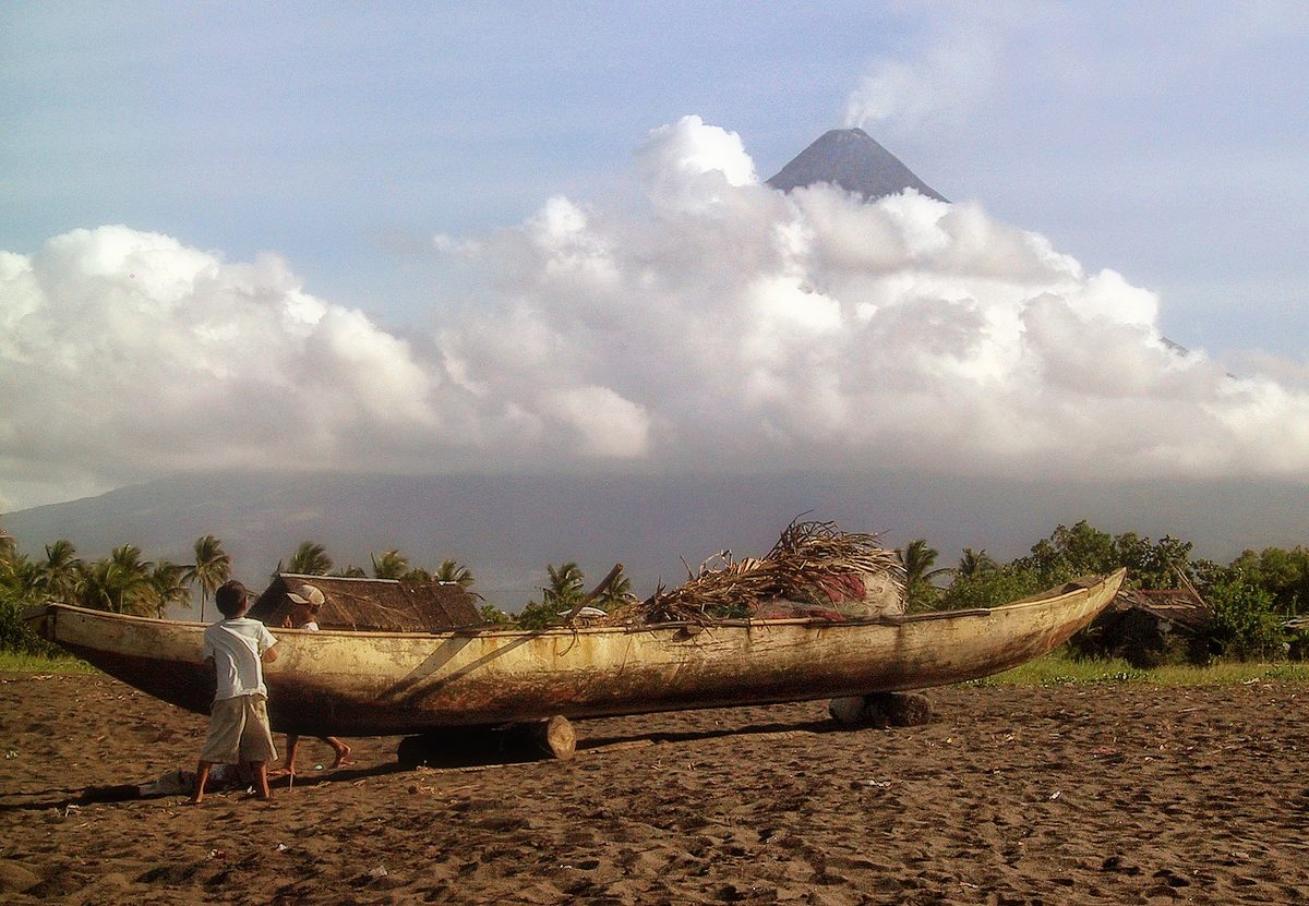
Southern Luzon delivers the drama: Mayon in Albay is the near-perfect volcanic cone, and Donsol in Sorsogon offers wild, ethical whale shark encounters. And then there is Palawan, administratively part of Luzon’s MIMAROPA region, home to El Nido’s limestone lagoons, Coron’s wrecks and lakes, and the Puerto Princesa Underground River. Off the far north, the Batanes islands trade palm trees for wind-scoured green headlands that look more like Ireland than the tropics.

Getting around Luzon
Manila’s Ninoy Aquino International Airport (NAIA) is the country’s main hub, with Clark (north of Manila) a growing second gateway. Within Luzon, overnight buses connect Manila to the northern mountains and to Bicol, and they are cheap and reliable if slow. For Palawan you fly: Puerto Princesa and the small El Nido airstrip are the usual entry points, since reaching it overland is impractical. The single most useful thing to know is that NAIA is the country’s principal connecting point, so even a trip that is mostly about beaches elsewhere often routes through Manila at least once.
The Visayas: Beaches, Diving and the Easiest Island Hopping
If Luzon is the head of the country, the Visayas are its sun-warmed middle: a cluster of medium-sized islands packed close together in the central seas. This proximity is the Visayas’ secret weapon. Nowhere else in the Philippines can you island hop, dive, and base-hop with so little effort, because the islands are near enough that fast ferries stitch them together in an hour or two.
What the Visayas are known for
The regional capital is Cebu, and the Cebu hub deserves its reputation: the Moalboal sardine run, canyoneering to Kawasan Falls, thresher sharks off Malapascua, and the lechon that Anthony Bourdain called the best pig he had eaten. A short hop away, Bohol pairs the surreal Chocolate Hills with the fragile, saucer-eyed tarsiers of Corella. Boracay, off the tip of Panay island, is the country’s most famous beach, a four-kilometer arc of powder sand and sunset sailboats. Negros (now the heart of the new Negros Island Region) brings Apo Island’s turtles and the dolphin-rich Tañon Strait. Siquijor leans into its folk-magic reputation and rewards you with mellow beaches and the swimmable turquoise tiers of Cambugahay Falls. And the festivals here are the country’s loudest: Sinulog in Cebu City and Ati-Atihan in Kalibo, both in January.
The eastern Visayas, covering Leyte and Samar, see fewer foreign visitors but reward the curious with Sohoton’s caves and natural bridges, and they carry real historical weight as the site of the World War II Leyte landings.

Getting around the Visayas
This is the easiest island group to travel, full stop. Cebu’s Mactan airport is a major hub with direct international flights and dense domestic connections, so many travelers skip Manila entirely and use Cebu as their base. From there, fast ferries (OceanJet and others) run to Bohol, Negros and beyond on frequent daily schedules, and the islands are close enough that a 9am departure has you on a different island by lunch. For Boracay you fly into Caticlan (closest) or Kalibo, then take a short boat transfer. If you only have a week and want sun without complication, the Visayas are the answer.

Mindanao: Surf, Volcanic Islands and an Honest Safety Note
Mindanao is the large southern island group, the country’s second biggest landmass plus its surrounding islands. It is the most culturally distinct of the three: home to most of the country’s Muslim Filipino population, a strong Indigenous (Lumad) presence, and the autonomous Bangsamoro region. It is also the part of the Philippines most tangled up in outdated assumptions, so this section needs both enthusiasm and honesty.
What Mindanao is known for
The standout for most travelers is Siargao, one of the country’s best islands and a teardrop-shaped surf island off the northeast coast. Cloud 9 is its world-championship wave, but the island converts non-surfers too, with the jungle-walled Sugba Lagoon and the tide-pool theater of Magpupungko. Nearby Camiguin, an island built by seven volcanoes, offers a Sunken Cemetery marked by a cross in the sea and the dazzling White Island sandbar. Davao, the south’s biggest city, is the gateway to Mount Apo (the country’s highest peak at 2,954 meters), the durian capital, and home to the Philippine Eagle Center. Surigao del Sur hides the sapphire Enchanted River and the wide curtain of Tinuy-an Falls. This is the Philippines with the volume of crowds turned down, and a good share of the country’s off the beaten path destinations sit down here.

Is Mindanao safe? The honest, current answer
Yes and no, and the distinction is geographic. Mindanao is large, and lumping it together as “dangerous” is both unfair and inaccurate, but so is pretending the whole island group is risk-free. Here is the current picture, drawn from the US State Department advisory (Level 2 overall for the Philippines, most recently reissued after periodic review in May 2026) and corroborated by other governments’ guidance.
- Areas under a “Do Not Travel” advisory: the Sulu Archipelago and the southern Sulu Sea (in the far southwest), and Marawi City, due to terrorism, kidnapping and the lingering aftermath of past conflict. No itinerary on this site goes anywhere near these.
- Areas under a “Reconsider Travel” advisory: most other parts of Mindanao, broadly western and central Mindanao and the BARMM region, due to crime and the historical risk of kidnapping.
- The well-trodden tourist areas: Davao City, Davao del Norte, Siargao and the Dinagat Islands are explicitly carved out of the higher warnings and are considered the safe, mainstream part of Mindanao. Camiguin, reached via Cagayan de Oro or by ferry, is likewise a long-standing, welcoming tourist island. These are where the surfers, divers and ordinary travelers go, in large numbers, without incident.
My practical take: Siargao, Camiguin and Davao are as safe to visit as anywhere in the Visayas, and you should not let a blanket “avoid Mindanao” warning rob you of them. But do check your own government’s current advisory before you book, fly directly into the safe gateways rather than crossing the island overland, and steer well clear of the southwest. One more current note: a significant earthquake struck parts of Mindanao in mid-2026, so if you are traveling soon, check for any active geological or weather advisories from PHIVOLCS as well.

Languages and Culture by Region
One of the first surprises for travelers is that “Filipino” is not the only language you will hear, and the differences track the island groups closely. The Philippines has two official languages, Filipino (which is based on Tagalog) and English, and English is genuinely widely spoken, which makes the country one of the easiest in Asia to navigate as a visitor — and the single biggest point in its favor when travelers weigh the Philippines against Thailand. Below that national layer, though, there are well over a hundred regional languages.
In Luzon, Tagalog is the mother tongue of the Manila area and much of the south, while the north has its own languages: Ilocano along the coast, Kapampangan in Pampanga, Bicolano in the southeast, and a cluster of Cordilleran languages in the mountains. In the Visayas and across much of Mindanao, the dominant language is Cebuano (often just called Bisaya), with Hiligaynon in the western Visayas and around Iloilo and Bacolod, and Waray in the east. Mindanao adds its own layer of Muslim and Indigenous languages, including Maranao and Tausug in the Bangsamoro areas.
You do not need to learn any of these to travel well, since English carries you almost everywhere. But knowing that “salamat” is thank you in Tagalog while a Cebuano speaker might say “salamat” too (the word is shared) and that a friendly “maayong buntag” means good morning in Bisaya will earn you warm smiles. The cultural texture shifts as you move south, too: Luzon and the Visayas wear a heavy Spanish-Catholic inheritance of fiestas and centuries-old stone churches, while Mindanao carries a stronger Islamic and Indigenous influence that gives its food, dress and architecture a distinct character.
The Regions of the Philippines, Explained for Trip Planning
Understanding the regions of the Philippines is not just trivia, it changes how you route a trip. Because the country is spread across three island groups and 18 regions, the single biggest planning mistake I see is trying to do too much across too many islands and spending half the holiday in transit. Here is how to think about it instead.
Pick one or two island groups, not three
For a first visit of one to two weeks, choose one island group and do it properly, or pair two that connect logically. A classic two-week first trip combines a slice of the Visayas (Cebu and Bohol) with Palawan in Luzon’s MIMAROPA, flying between them. A culture-focused trip stays in Luzon and runs the northern loop of Banaue, Sagada and Vigan before finishing in Manila. A surf-and-volcano trip pairs Siargao and Camiguin in Mindanao. Trying to touch all three groups in a single two-week trip is the recipe for exhaustion.
Route through the two big air hubs
The practical engine of any cross-group trip is domestic flights, and they almost always route through one of two hubs: Manila (NAIA) in Luzon or Cebu (Mactan) in the Visayas. Cebu Pacific, Philippine Airlines and AirAsia connect these hubs to dozens of smaller airports cheaply, especially if you book ahead and travel with carry-on only. As a rule, if you are combining Luzon with anywhere south, you will likely connect in Manila; if you are bouncing around the Visayas and the safe parts of Mindanao, Cebu is the smarter base. For everything else on the ground, the fast ferries of the central Visayas and the Grab ride-hailing app in cities fill the gaps. Our guide to getting around the Philippines goes deep on ferries, flights and jeepneys if you want the full transport picture.
Plan around the seasons and the calendar
The national dry season runs roughly December through May, which is the prime window for island hopping and diving across all three groups, with January to April the safest for boats. June to November brings the southwest monsoon and typhoon risk, though it is not a write-off: Siargao’s surf actually peaks August to November. Two windows to avoid unless you book far ahead are Holy Week (the week before Easter) and Christmas through New Year, when the entire country travels at once and transport sells out. When you are ready to turn this into a day-by-day plan, our Philippines itinerary routes lay out exactly how to sequence a trip across the groups, and the broader menu of things to do in the Philippines helps you decide what to build each leg around.
Frequently Asked Questions
How many islands does the Philippines have?
The official count is 7,641 islands, confirmed by the national mapping agency NAMRIA using modern radar surveys. The older, widely quoted figure of 7,107 came from a 1940s survey and is now out of date. The roughly 500 additional islands are mostly tiny, uninhabited islets the earlier survey missed; only around 2,000 islands in total are inhabited.
What are the 3 main island groups of the Philippines?
From north to south they are Luzon, the Visayas and Mindanao. Luzon is the largest and holds the capital, Manila, plus the rice terraces and Palawan. The Visayas are the central cluster known for beaches and the easiest island hopping. Mindanao is the large southern group, known for surfing in Siargao, volcanic islands and a distinct culture.
How many regions are there in the Philippines?
As of 2026 there are 18 administrative regions: 8 in Luzon, 4 in the Visayas, and 6 in Mindanao. The count rose from 17 to 18 in June 2024, when Republic Act No. 12000 re-established the Negros Island Region, grouping Negros Occidental, Negros Oriental and Siquijor into their own region.
Is Mindanao safe to visit?
Parts of it, very much so. Davao City, Siargao, the Dinagat Islands and Camiguin are mainstream tourist destinations that millions visit safely, and they are explicitly excluded from the higher travel warnings. The Sulu Archipelago, the southern Sulu Sea and Marawi City carry “do not travel” advisories, and much of western and central Mindanao is “reconsider travel.” Check your government’s current advisory and stick to the safe gateways.
Is Palawan in Luzon or the Visayas?
Administratively, Palawan is part of Luzon, sitting within the MIMAROPA region. Many travelers assume it belongs to the Visayas because its island-hopping culture feels similar, but officially it is grouped with Luzon. It is the best example of how the island groups and the administrative regions are two different ways of organizing the same country.
What language do they speak in the Philippines?
The two official languages are Filipino (based on Tagalog) and English, and English is widely spoken, which makes travel easy. Beyond that, more than a hundred regional languages are in daily use: Tagalog and Ilocano in Luzon, Cebuano (Bisaya), Hiligaynon and Waray across the Visayas and Mindanao, and Muslim and Indigenous languages in the Bangsamoro south.
Final Thoughts
The Philippines looks intimidating on a map and turns out to be one of the most rewarding countries in Asia to actually travel, precisely because its structure is so clear once you learn it. Three island groups, north to south. Eighteen regions. More than seven and a half thousand islands, only a couple of thousand of them inhabited. Pick your group, route through Manila or Cebu, give each place enough time to surprise you, and the archipelago stops being a puzzle and starts being the trip of your life.
Sources and photo credits
Photo Credits
- Mayon Volcano, Albay (Luzon) — Photo: Ray in Manila / CC BY 2.0 via Wikimedia Commons
- Banaue rice terraces (Luzon) — Photo: CEphoto, Uwe Aranas / CC BY-SA 3.0 via Wikimedia Commons
- Chocolate Hills, Bohol (Visayas) — Photo: Vyacheslav Argenberg / CC BY 4.0 via Wikimedia Commons
- Cebu city skyline (Visayas) — Photo: P199 (CC0) via Wikimedia Commons
- Davao region (Mindanao) — Photo: Eastern Mindanao Command, Armed Forces of the Philippines (AFP) (CC0) via Wikimedia Commons
- Cloud 9, Siargao (Mindanao) — Photo: Lokesh Ramachandra / CC BY-SA 4.0 via Wikimedia Commons
Sources
- National Mapping and Resource Information Authority (NAMRIA) — official source for the 7,641-island count.
- Philippine Statistics Authority (PSA) — creation of the Negros Island Region and the 18-region structure.
- Official Gazette of the Philippines — Republic Act No. 12000, the Negros Island Region Act (2024).
- US Department of State — Philippines Travel Advisory — current advisory levels for Mindanao and the Sulu region.
- Philippine Department of Tourism — official national travel portal.
About this guide: PhilippinesTourism.org publishes independent, on-the-ground Philippines travel guides. Information verified June 2026.
1 response
Comments are closed.